
robust reconstruction of
pavement responses [rPAVE]
using deflection slopes or deflections from Traffic Speed Deflection Device (TSDD) data
advancing TSDD measurements with rPAVE
Current TSDDs either use Doppler lasers to measure pavement deflection velocities, which are converted into deflection slopes by dividing by the vehicle speed and subsequently used to calculate deflections, or use distance-measuring lasers, where deflections are determined through triangulation. Doppler-based devices are the most common and can report pavement responses at much smaller spatial intervals than distance-based systems.
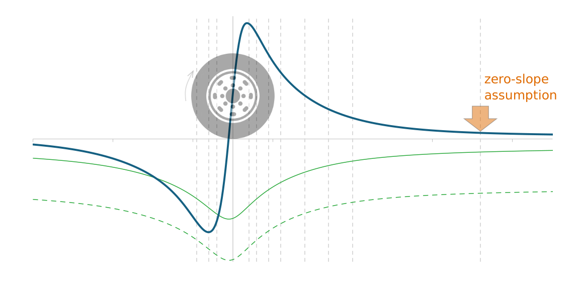
For Doppler-based devices, the measured velocities include both the pavement response and the motion of the measurement system itself. Since the measurement system moves with the vehicle, it cannot directly measure absolute pavement deflection velocities. To estimate and remove the motion of the measurement system from the measured velocities, one or more reference lasers are positioned approximately 3.0–3.5 m ahead of the instrumented axle, and the deflection slope at the reference location is assumed to be zero—an assumption that is rarely valid and can introduce systematic error into the measured deflection slopes. In addition, the measurement system is typically mounted on a combination truck with a large distance between the drive axle and the instrumented axle to minimize the influence of the tractor on the measured pavement response. However, this measure does not fully achieve its intended purpose because the tractor still contributes to the measured pavement response.
Furthermore, while deflection slopes are unique, deflections are not. Different deflection basins, shown below in green, can produce identical deflection slopes, and therefore the deflections calculated from those slopes are relative rather than absolute. This relativity does not affect certain deflection basin indices that are calculated as differences between deflections. Moreover, because every TSDD travels within the deflection basin produced by the entire vehicle, no TSDD can directly measure absolute deflections. Fortunately, deflection slopes—whether by design or by mistake—are sufficient to reliably determine pavement layer properties through backcalculation for structural evaluation.
To overcome these limitations, particularly the long-standing zero-slope assumption and the reliance on combination trucks, which limits the application of TSDDs on city streets, pulsuus developed a patent-pending methodology that uses local representations to reliably determine the vertical offset of the sparse deflection slopes beneath any vehicle, whether a combination truck or a single-unit truck, and reconstructs the complete deflection slope profile, from which the corresponding deflection profile is calculated. Previously, sensors were aggregated ahead of the instrumented axle to position the reference laser at 3.0–3.5 m, as required by the zero-slope assumption; this constraint no longer applies, and the measurement system can be moved backward to better capture the deflection slope — which reflects the unique shape of the basin — while also reducing the noise-to-signal ratio where slope measurements are higher.
The methodology also supports the reverse process by reconstructing pavement responses from deflections and computing the deflection slopes required for backcalculation. Robust to both random and systematic errors, this methodology forms the foundation of
rPAVE (robust reconstruction of pavement responses), a web application for reconstructing pavement responses from TSDD measurements.
no zero-slope assumption
reconstruct the continuous deflection slope and deflection profiles, leading to more accurate structural evaluations, including subgrade layer moduli estimation and backcalculation
reposition sensors to capture the full basin shape
move the measurement system backward relative to the mainly one-sided standard configuration, which also reduces the noise-to-signal ratio where slope measurements are largest
any vehicle type
install the measurement system on combination trucks or single-unit trucks, without restriction
robust to noisy sparse data
reconstruct cleanly around gaps, outliers, and missing sensors
works from deflections or deflection slopes
reconstruct either direction, whichever is measured
no FWD required
only needed for limited verification
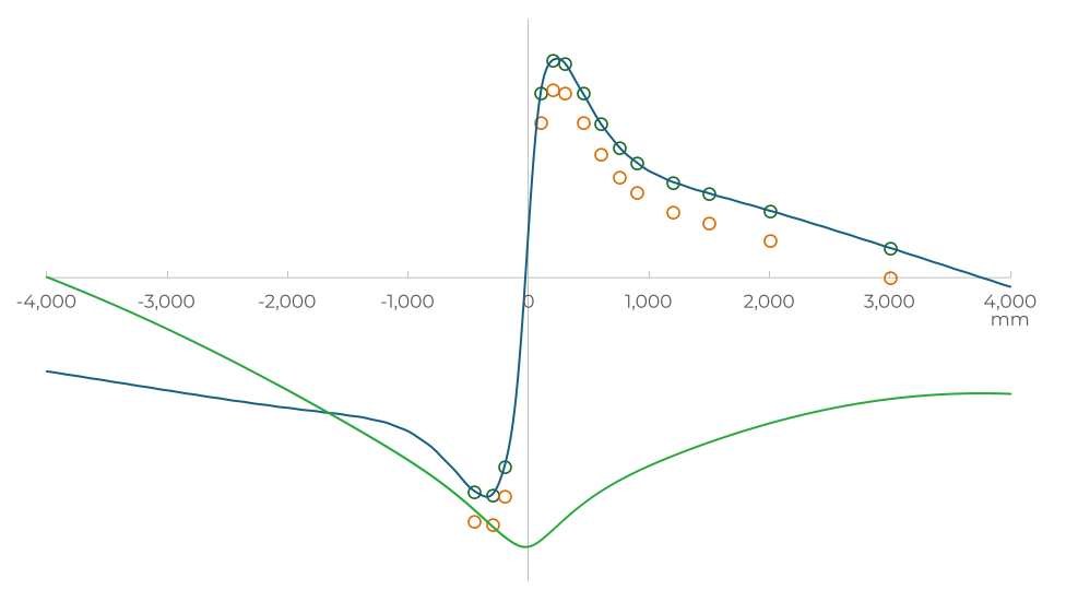
example of rPAVE reconstruction compared with the zero-slope assumption
The green circles show the deflection slopes aligned by rPAVE, representing the true deflection slopes. These aligned measurements are used to reconstruct the complete deflection slope profile (blue) and the corresponding deflection profile (green), extending both beyond the measurement range. The orange circles show the same measurements constrained by the conventional zero-slope assumption. At the 3 m reference location, the systematic error introduced by the zero-slope assumption is clearly evident.
rPAVE in action
The examples below begin with synthetic data after introducing random measurement errors, using deflection slopes under a single-unit truck and deflections under a combination truck. The target profiles confirm reconstruction accuracy despite the presence of random error. The examples that follow use real field data covering different scenarios of small deflection slopes with large noise-to-signal ratio, and outliers or missing sensor data.
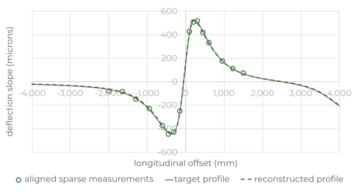
deflection slopes under single-unit truck
aligned and reconstructed deflection slopes under a single-unit with short wheelbase (4.5 m) with sensors from -2 m to +1.5 m.
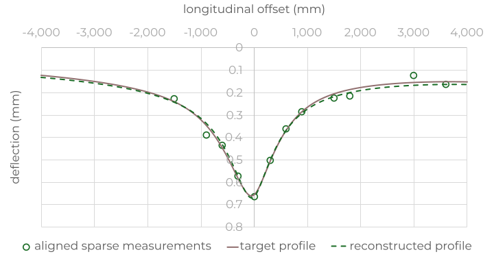
deflections under combination truck
aligned and reconstructed deflections under a combination truck, from which deflection slopes can be calculated.
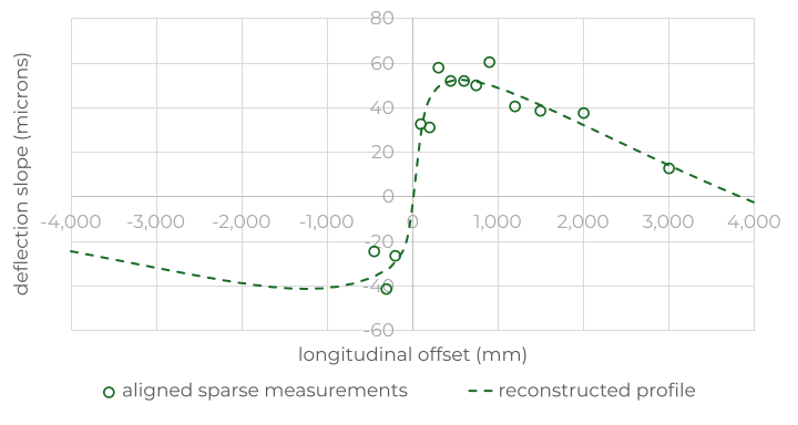
high noise-to-signal ratio
an aged flexible pavement with a highly stabilized base — small deflection slopes reconstruct into a clean, smooth profile despite high noise.
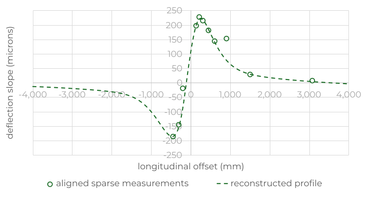
outliers
a flexible pavement with a relatively stiff subgrade, including two significant outliers at −200 mm and +900 mm.
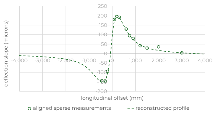
outlier and missing sensor
a flexible pavement with a lime-stabilized subgrade, an outlier at +2,000 mm, and a missing sensor at +450 mm.
rPAVE free trial
50,000 shared credits over 7 days, for up to 3 users per company — equivalent to analyzing 500 km at 10 m or 500 miles at 0.01-mile intervals. No payment method required.
Trial access is subject to approval and governed by the rPAVE Terms of Service (Section 6 covers free trials) and the pulsuus Privacy Policy.
